31 March 2011

The new Touraine map

A few weeks back, I mentioned the map of the Touraine vineyards that we were having framed (here and here). It will look good on the freshly painted white walls in our stairway or upstairs in the loft. Walt got the map back from the framing shop while I was away in North Carolina.

Touraine vineyards, including the Loir River area to the north —
the Loir runs parallel to the Loire and eventually flows into it.

So here it is. As I said, it is not yet hanging on a wall. First we have to paint the walls. One day that will happen.

(Don't forget that you can click on the pictures to see them at a larger size. If you see the little magnifying glass with a + in it, click again to enlarge the picture even more. Then click the back arrow on the upper right of your screen to return to the blog topic.)

Progressively closer views — here you can see the vineyards
from western Touraine (Chinon and Bourgueil) over to the
far east (Blois, Saint-Aignan, Valençay), as well as the Loir.

It's not easy to take a picture of a map that is 36" wide by 27" tall (that's 900 mm x 700 mm), especially when it's behind plexiglass. You can see, however, that we chose a frame that picks up the red colors of graphics and text on the map.

Here's the eastern Touraine, showing the Cher and Loire river valleys.
Saint-Aignan is directly to the east of the word Touraine on the map.

On other subjects, I'm making a big dish of coq au vin this morning — I had some red wine I wanted to use in cooking, and chicken sounded better than beef for a bourguignon. The chicken in red wine sauce will go into the oven before we go out to do some errands today.

It's still raining outside.

The view out the loft windows on a recent afternoon

I realized this morning that I didn't take any pictures of the duck breast that I salted down to make jambon de magret de canard (or in good English, duck breast proscuitto). Yesterday I took it out of the salt, wiped it clean, sprinkled some black pepper and herbs on it, and then wrapped it in a kitchen towel to cure in the refrigerator for three weeks.

Check back in late April for the result. Maybe the rain will end before then.

30 March 2011

Singing in the rain

It rained yesterday and I had an allergy attack. The wind blew from the south and brought up some kind of pollen that attacked my eyes and nose. It was like having somebody stick needles into the lining of my nasal passages after having sprinkled fine sand into my eyes.

But I'm used to it. It's a pattern, and there's some cold comfort in knowing that. Today I will be better, after I walk the dog and take a shower. I hope. According to the weather report I just saw on Télématin, the news is that there are three wet weather systems affecting French territory today. They say it's unusual to have three systems over the country at the same time.

Walking down toward the river with the dog
yesterday afternoon


Late yesterday afternoon, following an impromptu visit from Nick of Nick and Jean at A Very Grand Pressigny — he was doing a test run on his motorcycle in preparation for the long ride back to England today — I took the dog out for her afternoon stroll. The rain had stopped but there were still big puffy clouds in the sky. We walked north through the woods, a ways east past woods and fields, and then south along the Rue des Laurendières down in the river valley.

La rue des Laurendières, parallel to the Cher River
down in the valley, is a dirt track.


A big anvil-shaped cloud formed over a field of colza (a variety of oilseed rape) that is just bursting into flower down below. Suddenly it started raining, and Callie and I were about as far from the house as that particular route takes us. Of course. Luckily, I had thrown on my rain gear for the walk and Callie doesn't mind getting wet.

Our house is up the hill on the other side of the woods
in this photo.


The rain lasted just long enough for me to get good and soaked as I climbed the hill and arrived back at the house. It wasn't unpleasant though. I just hope it doesn't happen again this morning. It's about time for the first walk of the day.

29 March 2011

Rainy day activities

We are having a rainy week and we need the rain so no complaining. It's amazing how fast the ground here can dry out. We had so much rain all winter, but no matter. It's archi-sec outdoors now — or was until Sunday.

So what do you do on a rainy Monday? Especially on a Monday when there's not cooking to do because lunch is leftovers? Well, a major computer upgrade, that's what. Yesterday Walt installed Windows 7 on his seven-year-old computer.

One thing I brought back from the states was a pair of 1 GB memory chips — DDR PC-3200 memory modules — for Walt's Dell 4600i, which he bought in 2004. That brought him up to 3 GB of RAM in preparation for the Win7 install.

When a computer is that old — in dog years, one year equals seven, and it's about the same for PCs — you have to expect problems. Surprisingly, there weren't that many. The main one that cropped up has to do with the on-board Intel video adapter in the old Dell. That adapter does not support something called DirectX, so you can't customize screen colors as easily as with a DirectX-compatible adapter. Maybe a new graphics adapter is in order — and on order.

I'm expecting the pond to start overflowing again.

There were some problems with importing bookmarks into Firefox, but those mostly got resolved. The old bookmarks were saved by the installation program, I think. But finding them is not that easy. I'm not sure about the status of all that. By the way, all the old applications have to be re-installed too. And we've got a new version of Microsoft Office to deal with too — Walt uses Office, but I don't.

Last week's feu de jardin

There's a new version of Photoshop Elements to learn and explore. I brought that back from the U.S. too. The version we had before was in French, so not only do the menus in the new version have commands in different places and orders, but now they are named in English rather than French. How do you say accentuation, renforcement, or calque in English? We'll have to figure it out.

All in all, there were no major hiccups in the installation process. The Win7 installer was slow and the installation was long, but it went smoothly, saving the old Windows XP files so that W. could go back and find the documents and photos he didn't want to lose. He had backed up all his photos to a separate hard disk, so that they were safe and sound.

A new rain front is moving in today, so more computer configuring and cursing are going to be the main activities around here. Meanwhile, our spring crops — collard greens, mustard greens, salad greens of different kinds, radishes, and leeks — are getting a good soaking. It's just what they need.

28 March 2011

Sarkozy's party the loser in local elections

Local elections were held across France yesterday. These elections are called the cantonales — the canton is an electoral district in a département, of which there are about 100 in France. The winners of the cantonales become "departmental councilors" — the closest American equivalent would probably be county commissioners.

Our département, for example, the Loir-et-Cher, is made up of 30 cantons, one of which is centered on Saint-Aignan. The Blois area — Blois is by far the largest town in the département and is its administrative "capital" — is divided into five cantons.

Analysts are saying that the big loser in these local elections was the UMP party headed by current French president Nicolas Sarkozy (age 56). And the big winner, politically, was the party that up to now has been called the French "hard right" — the Front National, headed up by a 42-year-old woman named Marine Le Pen, the daughter of FN founder Jean-Marie Le Pen (age 82). The UMP got 20% of the total vote nationally, and the FN got about 12%.

The Front National didn't win many seats on departmental councils this time, but it greatly increased its share of the vote. That's a bad sign for Sarkozy and his center-right party.

The winner in terms of percentage of votes won was the Parti Socialiste, with 36%. The abstention rate was very high, with fewer than half the eligible voters actually going to the polls. Even so, on the right, Le Pen's Front National seems to be on the rise and Sarkozy's UMP seems to be on the decline. My impression is that Sarkozy has adopted policies and rhetoric aimed at pulling more right-wing voters into his party, but his efforts have backfired by giving the extreme-right FN new respectability.

All this is important in France because it shows the current balance of political power just about a year before the next presidential elections are to be held. Sarkozy will in all likelihood be a candidate for re-election. The socialists haven't yet chosen a candidate. Marine Le Pen will run.

If Sarkozy and Le Pen divide the right-wing vote, it will be easier for the socialist candidate to win a majority in the presidential polling. The election takes place in two rounds, and the final result depends on who the two top vote-getters are in the first round.

In 2002, for example, the two top vote-getters in the first round of voting were the two right-wing candidates, the center-right incumbent president Jacques Chirac and the extreme-right challenger Jean-Marie Le Pen. The socialist Lionel Jospin, then Chirac's prime minister, was eliminated. In the second round of elections, Chirac defeated Le Pen with more than 80% of the vote.

At this point, polls show Sarkozy being eliminated in the first round of next year's presidential elections. In a second round opposing a Parti Socialiste candidate and FN's Marine Le Pen, the socialist would win handily. Still, the presidential election is 13 months away...

By the way, don't let the word "socialist" confuse you when it comes to the Parti Socialiste Français. It is the center-left party, and the largest party on the left side of the political spectrum in France. It corresponds to the social democratic parties of other European countries.

The last socialist president was François Mitterand (1981-1995). Socalist Lionel Jospin was prime minister from 1995 until 2002. And the Parti Socialiste's presidential candidate, Ségolène Royal, got 48% of the vote against Nicolas Sarkozy in the second round of the 2007 presidential election.

27 March 2011

Lag, lagged, lagging

I should just take a day off. When I woke up early yesterday, I was optimistic. Then I went to bed at the normal hour last night and just lay there. Sleep would not come to me. I tossed. I turned. I got up and drank a glass of water. I went back to bed. Still, I did not sleep.

The flowering cherry tree out front

Finally I must have, and when I woke up, cramped and grumpy, it was 9:00 a.m. Well, by the clocks that Walt changed last night. It was really just 8:00 a.m. Or was it? What time is it really?

Peach blossoms, I think

I'm hoping for rain today. The last time I saw rain was on March 10, the day I arrived in North Carolina. The ground here is very dry indeed. If it doesn't rain, I'll need to go water my greens. If it does rain, I want to take a lot of potted plants out of the little sun porch and give them a good drink. Maybe they won't have to come back in this year.

26 March 2011

Petit à petit...

...l'oiseau fait son nid. That's what they say in French. "Little by little, the bird builds its nest." I'm doing that now — (re)building my nest.

When I woke up from my nap yesterday afternoon
I found that Walt had built a bonfire in the garden
.

I had a fairly normal day yesterday, in fact, except for sleeping in until mid-morning. I cooked lunch. I napped a little in the afternoon. I put away the things I took out of my suitcase the night before. I went out and walked the dog in the afternoon.

Wake up and smell the (prim)roses

Today I got up at 6:30. That's normal for me. So I'm getting back on schedule. This morning I'm going shopping to get some food for lunch, and some things I've been wanting to get before I left for North Carolina. For example, a duck breast — I'm going to make jambon de magret de canard. In American, I think they call that duck breast prosciutto. More about it later.

The neighbors' chickens

I still am one day off. Today really feels like Sunday. I know it's not, but I lost a day somewhere over the Atlantic, I guess. I'll find it again somewhere along the way.

25 March 2011

Day 1 back in France

I fell asleep on the sofa at 9:00 p.m. after my 30-hour journey. Walt woke me up and I moved to the bed, where I stayed until nearly 10:00 this morning. I'm still groggy.

When I got up I went down to the kitchen. Walt was nowhere to be found. I noticed that there was no fresh bread on the kitchen counter, even though the bread lady comes at 8:30 on Saturday mornings.

Walt cut down that old, half-dead apple tree this morning.
We'd been meaning to get it cut down for two years.


Then Walt appeared. He had been down in the utility room putting a new chain on the chainsaw, he said. "Why isn't there any fresh bread? Did you get any this morning?" I asked him. The bread lady hasn't come yet, he answered. No, I said, she comes early on Saturdays.

While I was gone, the collard seeds I sowed
nearly three weeks ago came up.
..

"Today is Friday," Walt said. That would explain it then, I thought. Still, I wasn't convinced he was right. It felt like Saturday to me.

...and the plum trees I planted three years ago blossomed out.

The sun was and is shining brightly outdoors. I went out and took some pictures. I need to make lunch; there's a big, beautiful cauliflower in the refrigerator. Cauliflower with cheese sauce. Here I go.

24 March 2011

Home

As CHM said, I left home to come home. The flight was easy, but the plane was full. At this point, I've slept about 30 minutes out of the past 30 hours. More later...

23 March 2011

A Moreheader born

Morehead City, North Carolina, celebrated its centennial in 1957, when I was eight years old. I remember it. There was a big parade downtown, near the waterfront, with marching bands, beauty queens, and floats.

The town was founded, then, in the 1850s, because of its potential as a deep-water port. N.C. Governor John Motley Morehead and a group of investors bought the land on what was known as Shepard's Point and began construction of a rail line from Raleigh to the coast. The town was laid out in a grid pattern called the Philadelphia plan, with H-shaped alleys running through blocks of 16 lots between north-south and east-west running streets.

A view of the port from the Morehead waterfront

The town waterfront was where "party boats" docked. They weren't boats that people (necessarily) had parties on. They took parties of fishermen out to the edge of the Gulf Stream to fish for marlins, swordfish, groupers, tuna, and other big game fish. There were also seafood restaurants — most notably the Sanitary Fish Market and Captain Bill's — and gift shops — Dee Gee's was the best known — and fish markets — Ottis's and Davis's — up and down the five or six blocks of docks and fish houses.

The alleys, unpaved, were like secondary streets. They were public rights of way, and residents could walk through them to find the most direct route to their destination. As children, we could always get to our friends' houses without having to go the long way around blocks on the sidewalks. It was like a town with many many shortcuts — it was and is pedestrian-friendly.

A white ibis feeding in a marsh near downtown Morehead

Morehead has been the biggest town in the county since I was a little boy, but the much older town of Beaufort, just three or four miles east, is the county seat. Nowadays, Morehead is also the biggest town in the county for shopping, restaurants, and other tourist services. The population is less than 9,000 — it has doubled over the past two or three decades — but the summer population of the area is much higher.

The town's most famous restaurant is the Sanitary Fish Market.
It's been in business since 1938 and can seat 600 for dinner.

My father and both my grandmothers were born here, of families that had been here for a couple of centuries. But both my grandfathers came from "off" — one from a town in North Carolina about 75 miles away, and the other from a town in South Carolina close to Charlotte, N.C. People are either local or from "off." I've even heard local people refer to people who live elsewhere as "foreigners."

On the waterfront

Morehead City remained a relatively isolated place until the 1940s, when the federal government built two big military bases in the area. As a result, many people from off moved in, or stayed after having served in the military nearby. The local brogue started being diluted by accents and dialects from other regions. Better roads were built. The economy grew, and people started buying cars and traveling.

Big "head boats" take fishermen out to the Gulf Stream, at
the edge of the continental shelf, for deep-water sport fishing.

When I was growing up, we had two cars. My father was a civilian employee at one of the military bases, and my mother started working when I was about 10 years old. She had her own car. In 1960, when I was 11, we took our first long road trip. We drove to Charlotte and the towns just south of that large city, over the border in South Carolina.

A sign on the door at the Sanitary

The drive took at least six hours back then. My mother's relatives — her father's sister and her first cousins — lived in a completely different world from ours, as I remember it. They had a farm. They milked their cows every morning and my mother's aunt churned her own butter. Being from South Carolina, they ate rice with every meal. They had a pump and a dipper in the kitchen for drinking water. And they spoke with the most outrageous Southern drawl you could imagine. We could hardly understand each other at times.

Tourists are discouraged from feeding the gulls
that swarm along the waterfront.

Out here on the coast, we were Southern but not too Southern. We were rural but not too rural. There were more fishermen than farmers. We lived in or near towns, because there wasn't a lot of land for farms and farming. We were coastal, and marshy. The Old South began just south of us, over the line in South Carolina. We spoke English with an Old English-sounding brogue, and we used a lot of old English terms and expressions that were considered old-fashioned or archaic in other parts of the U.S.

Go fishing off Cape Lookout...

If you ever come to Carteret County NC, drive Down East to Harkers Island, about 25 miles (40 km) from Morehead City by road and bridge. Go down to the eastern end of the island and go into the Core Sound Waterfowl Museum. If you're lucky, you'll get to talk to Jan Gillikin, who is a native Harkers Islander. She has the best local accent I've heard in a long time. She's enthusiastic and talkative, and very knowledgable when it comes to the local people, traditions, and history.

That's what we did yesterday. We spent half an hour talking and reminiscing with Jan. The displays in the museum are very well presented and informative too.

I've been here for two weeks now, and today I'm flying back to France. The weather has been gorgeous the whole time I've been here on the Carolina coast. The food is definitely good. The one thing I can't face is the heat and humidity of a Morehead summer. Everybody has air-conditioning now. We didn't when I was growing up. I don't know how we survived. That's why I like to visit in March — for the mild weather.

22 March 2011

Salter Path history and shrimp

Sunday afternoon MA and I took a drive down to Salter Path. We were just "ridin’ and lookin’," as we say, and when we got to Salter Path we saw signs along the road for two or three fish markets. One of them was open. I wanted to buy some fresh local shrimp, because I hadn't had any since my arrival.

Salter Path was first settled, at least seasonally, from the mid-19th to the early 20th century, mostly by families moving west and south down the Banks — the barrier islands — from an old whaling community called Diamond City, located near Cape Lookout. Local whaling was on the decline, because people no longer needed whale oil for their lamps. One source says the first permanent settlers established the village of Salter Path in 1896.

A map of Carteret County, North Carolina, showing Salter Path,
Morehead City, Beaufort, and Cape Lookout

The "Salter Pathers" were fishermen. They kept cattle, hogs, and chickens, and they had vegetable gardens in the sandy soil. They hunted and ate loons, ducks, robins, and other birds. They dug clams and harvested oysters and scallops. They traded salted fish — mullets, especially — for corn and sweet potatoes — with people on the mainland. They caught the fish by dragging long seine nets, which were made by the families themselves, in the surf when the mullet were "running" along the beaches. In later years, they used (and still use) tractors to haul in the nets.

The Willis Seafood Market in Salter Path

Salter's path was the path from the ocean beach to the sound shore across the narrow strip of sand called Bogue Banks. People lived on the sound side but worked on the ocean side to catch mullets. The path was near the Salter family home. The other families at Salter Path were named Guthrie, Gould, Dixon, Smith, Willis, Adams, and Lewis. They were all squatters — they held no title to the land they lived on. The village of 33 hectares (80 or so acres) was bought by a man from Boston in the early 20th century and the settlers were allowed to stay.

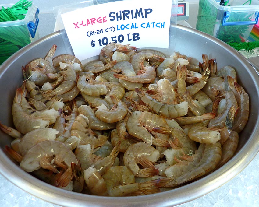
North Carolina "brown shrimp" from the Willis Seafood Market

It was only in 1979 that the Salter Pathers finally got title to their land, after they took the case to court. Of course, then they started having to pay property taxes. The children of the Salter Path families went to elementary, junior high, and high schools with us Moreheaders, first at the old town school and later at a consolidated high school that served the whole western end of the county. The Salter Pathers spoke English with a slightly different old English brogue from ours, so they were easy to recognize.

Vesta Willis's specialty is home made crab cakes,
made with the flesh of the Atlantic blue crab
(
Callinectes sapidus— "beautiful, savory swimmer").

I'm not sure when the paved road from Morehead City to Salter Path — about 10 miles/16 km — was built, but it was after the first bridge from the mainland to the barrier island was built in the 1920s. For years after the bridge was built and before the road was built, I've been told, the Salter Pathers would drive their trucks along the beach on hard sand at low tide, day or night, to get to Atlantic Beach and Morehead, where there were restaurants, dance halls, and movie theaters.

Don't these look good?

When I was a little boy, the paved road ended at Salter Path, or a couple of miles beyond the village. Then there was a stretch of wild beach and dunes for another 15 miles down to the end of the island at Bogue Inlet. By the time I was in high school, the road had been extended through that section and the "land" (sand) was being developed for tourists with beach cottages and motels.

At Willis Seafood in Salter Path

MA and I drove to Salter Path and turned off to see if the Willis Fish Market was open. It was. The woman who owns it, Vesta Willis, greeted us. She was very talkative and curious to know who we were. We knew a lot of the same local people. She told us she had grown up in Morehead City and had married a man from Salter Path when she was 16 (in 1957).

Nowadays Salter Path is also a beach resort...

I believe she said her husband had passed away a few years ago, but I'm not sure about that, or what this Mr. Willis's first name was. (My maternal grandmother was a Willis from Morehead City.) She talked about what life in Salter Path was like in the 1950s and 1960s. How small the houses were, how minimal the creature comforts were, how everybody helped everybody else to survive.

...and here's somebody enjoying the bright mid-March sun.

Looking back on it, we were all very poor back then. But we didn't suffer, except from the rare cold spells in the winter and the blistering heat in the summer. Not to mention the mosquitoes, horseflies, sandspurs (we children mostly went barefoot in summer), and hurricanes. You got used to the summer heat and humidity, and there was usually a sea breeze at night. On stormy nights, from my bedroom window a mile as the gull flew from the beach, I could hear the surf pounding the shore. Just think what that sounded like in Salter Path.

I bought a pound of the local "brown" shrimp (Penaeus aztecus) from Vesta Willis, and we had a nice visit. I cleaned the shrimp (that means shelling and deveining them) at home and cooked them in a little oil in a frying pan. French Wikipedia says these are called crevettes royales grises in French — "royal gray shrimp." I seasoned them with salt and pepper only, because I just wanted the shrimp taste, and I cooked them until they were barely done. They were right fittin'.

21 March 2011

More about New Bern

Back in the 1930s and '40s, people in my home town — Morehead City, N.C. — used to take the train to go to New Bern. Passenger train service ended many years ago, however, and by the time I was growing up in the 1950s and '60s, every family had a car — or two. We drove to New Bern.

We went to New Bern to go shopping. Up there, 35 miles from home, they had J.C. Penney's, Woolworth's, Sears & Roebuck, and other big stores that we didn't have in Morehead. There were no malls or even strip malls in those days. People shopped downtown. They dressed up to go shopping.

New Bern city hall, decorated with
the town's mascot, the black bear


That's what I remember. We had a friend — the daughter of a neighbor, a quasi-cousin — who married a man from New Bern and went to live up there. When she and her children would come home to visit her parents, it was almost as if we were being visited by people from the city. In a remote place like the one we lived in, New Bern was the outside world.

This New Bern house has a shady, spacious front porch
and grand columns at the main entrance
.

Don't get me wrong. I grew up in a very special place. It was far from the cities, the weather was mild and sunny, and the beaches were long and uncrowded. Seafood was plentiful. Everybody seemed to know everybody, and children played outside, unsupervised — their parents didn't have to worry about them. It was a world of corner grocery stores and long hot summers.

People in New Bern obviously have a sense of humor...

By the time I was in college (1967-71) New Bern was just an obstacle. You had to drive through the center of it on the highway that led from the coast to the Raleigh-Durham area. Most of the road was just two lanes then, one in each direction. If you got stuck behind a big truck, it was very slow going.

...and some interesting vehicles.

Nowadays, the population of New Bern has doubled. Actually, during the 1950s, '60s, and '70s, the town was losing population year after year. In the '70s, the population declined nearly 7%. Then, suddenly, the population grew by 20% between 1980 and 1990. It's still growing. Old neighborhoods, including the historic district, were spruced up and people bought houses and moved back into town.

This duck begged for food on New Bern's river walk.

Prices still are not prohibitive by national standards. In fact, houses in Morehead City, closer to the ocean, are priced higher. A lot of people from other states and cities would be able to do what I did when I moved to France — sell an expensive house in another area and buy an equivalent house in New Bern for a lot less money.


The house in the pictured above, built in 1848, has three stories, four bedrooms, and four bathrooms, with separate living and dining rooms. It also has seven fireplaces and central air conditioning. It's over 300 square meters (3,200 sq. ft.) of living space and annual property taxes come to about $3,800 U.S. (2,700 €).

The selling price for this place, the Jerkins-Richardson house, is $620,000 (440,000 €). To me that's a lot, but this is a magnificent and historic house, judging from the pictures on the real estate agent's web site. I see many other nice houses in the New Bern historic district that are priced much lower.

20 March 2011

A walk in New Bern

On Friday afternoon my sister and I took a drive up to New Bern. It's about 35 miles from the town where we both grew up. New Bern is the second oldest town in North Carolina — it was setteled in 1710. The population now is about 30,000. The town is located at the confluence of two rivers, the Neuse (pronounced as "noose") and the Trent.

I wanted to go to New Bern to walk around and take pictures in the old historic district. On this trip to North Carolina, I haven't gone on any road trips like the ones I've taken with my mother over the past few years. New Bern, a town where we have always gone to do shopping, because it's a lot bigger and has more stores than Morehead City, remained a place I didn't really know very well.

Old houses in New Bern's historic district

New Bern was the colonial capital of North Carolina, and it was also the first state capital (but it was the capital city for only a few years after independence from England). Raleigh, 100 miles to the northwest along the Neuse River, was established as the new capital of North Carolina in 1792. New Bern remained the largest town in North Carolina until about 1850, when it had a population of about 5,000.

North Carolina was settled later than its neighbors to the south (South Carolina) and the north (Virginia). The first English colony in Virginia was established at Jamestown in 1607. In South Carolina, Charleston was founded in the mid-1600s. By 1790, however, North Carolina had a population of about 900,000, compared to 1.1 million in Virginia. Today, N.C. is home to nearly 10 million people.

I liked this courtyard paved with bricks.

Before even the settlements in the neighboring states, Sir Walter Raleigh had attempted to settle colonists on the N.C. coast in 1584 or '85. Those colonies failed and all the settlers disappeared into the wilderness. Even so, the first English child born on American soil was born on North Carolina's Roanoke Island in 1587.

We noticed these turkey vultures on the town's riverfront walk.
Turkey vultures have a wing span of nearly two meters (six feet).


However, it was in 1710 when a group of Swiss and German settlers, led by a Swissman named Christoph von Graffenried along with the English explorer and naturalist John Lawson, established themselves on the site of present-day New Bern, North Carolina — hence the name of the new town. Lawson was captured and killed by the local Tuscarora tribe of Amerindians in 1711.

By 1770, the British had made New Bern into their capital city in North Carolina. They built a governor's mansion — Tryon Palace — but it burned in 1790, at the end of the War of Independence. In the 1950s, a replica of the old mansion was built on the original foundations and it has become New Bern's most popular tourist attraction.

A U.S. Postal Service vehicle in front of one of the old houses

There was a battle of New Bern during the U.S. civil war in the 1860s. New Bern was taken by Union (northern) forces — as opposed to Confederate (southern) forces — in March of 1862 and remained under Union control for the duration of the war.

There are a lot of big old houses in New Bern, dating back as far as the mid-1700s. They are part of a national registry historic district, the equivalent of France's Monuments Historiques. I'm posting photos of some examples here, in case you don't know what American houses from the 18th and 19th centuries look like.